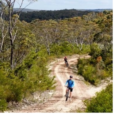
Enjoyable mountain bike ride along the most popular trail in the Blue Mountains. The ride is predominantly downhill but has some tricky climbs and a few more than tricky descents. Riders will need some previous MTB / Gravel experience, however suitable for almost everyone.
First roll along some open trails, see some Aboriginal rock engravings, a meander along a ridge looking into a spectacular valley. Then comes a gnarly downhill, and a gentle roll up to the helicopter landing pad. A quick stop and a play with the logs, then the beautiful 5km descent.
This route includes a side trip to see the remarkable Aboriginal rock art in Red Hands Cave.
The fun really begins after this, along a section of fast and flowing singletrack. There are some optional technical challenges for those with higher abilities and a popular easier alternative, along a well-made flowing sealed road.
The ride ends with a steep climb on-road back to Glenbrook station, where we retire to the bakery for lunch. Bring plenty of snacks and water - I recommend TWO water bottles in hot weather.
It is only suitable for ‘gravel’ bikes or mountain bikes (MTB). Do not attempt this ride on a road bike or with tyres less than 40mm width.
The route is usually suitable for riders with these minimum skill levels: intermediate on a gravel bike or beginner on an MTB.
Check the National Parks and Wildlife website to ensure the track is open and accessible: https://www.nationalparks.nsw.gov.au/things-to-do/cycling-trails/woodford-oaks-trail/local-alerts.
You must be self-sufficient with water, snacks, a first aid kit and be able to perform repairs such as punctures and slipped chains. There are no water refill points or toilets. Phone reception may be weak or non-existent. The weather may change, so ensure you have suitable clothing.
Important Considerations:
• Phone reception: Limited
• In hot weather this ride is not recommended. Carry ample water, as refilling options are unreliable.
• Bring snacks and a first aid kit.
• Ride with a safe stopping distance, especially on downhills.
• Do not rely on riders ahead to choose the correct line or speed.
• Hazard calls for obstacles such as rocks and sticks may be too frequent, so stay alert and scan the trail ahead.
• Trail surface may have changed due to wet weather, erosion and maintenance.
• River crossings, if any: Weir.
Regroup Points:
• Multiple stops, as needed, including Oaks picnic area at 10km and helipad at 15km
Distance: 37.00
Elevation Change: 520
Ride with GPS
Check public transport alerts: www.transportnsw.info/alerts#/metro-train
Risk warning
As a participant in this dangerous recreational activity, you may be exposing yourself to a significant risk of harm.
Bike North, the ride organisers and leaders wish to warn you of the risks and hazards that are an inherent part of cycling,
and to take care to prevent putting yourself, your fellow participants and/or others into danger.
By registering for this ride, you accept the warning as to risk, and you agree to ride in a safe and responsible
manner and to obey all road rules and other legal requirements.
All riders wear an approved helmet and carry water, at least one spare tube plus a pump.
Health warning
Riders must not attend if sick, have Covid-19, influenza or symptoms of any communicable disease.
Social media
While on Bike North rides and activities, you may be photographed or videoed. Photographs and videos
may be used by Bike North for social media or promotional purposes. If participants do not wish to be
included in social media, they should make it known at the beginning of the activity or as soon as possible
and other participants must respect their wishes.